September may have been cooler than average and the coldest since 2001 (Newton Rigg) and back to 1994 at some locations, but despite this it would probably be considered to have been a decent month as it was both notably drier and sunnier than average. Night-time minima were drastically below average by some 2.0°c, whilst day-time maximums were only marginally below average. The cool nights were a constant theme throughout the month, with two ground frosts recorded and whilst we also had a number of cool days, there was the occasional warmer day, especially during the excellent spell at the month's end.
Any rainfall was also kind enough to fall overnight or in the form of showers and the month was dry at both its start and end and contained some really fine sunny days. However, the month started cold with a north-westerly flow before improving significantly for the 6-11th and which like the 25-30th were fine, sunny, warm and quite summer-like.
MSLP of 1017.8 Mb was +3.7 Mb above the average for September with high pressure very much in the ascendancy and for notable periods at a time and hence the low monthly rainfall total. Even when the pressure was at its lowest (991.1 Mb - 16th) it was within a slack pressure gradient and the day was lovely and sunny!
Overall a mean minimum of 6.33°c and a mean maximum of 16.49°c saw the temperature 0.9°c below the 1981-2010 average, making it the coldest September that I have yet recorded. The highest maximum temperature recorded was 20.7°c (10th), the lowest minimum 1.7°c (16th).
Rainfall of 32.5 mm (Crosby Ravensworth School 30.3 mm) made it the wettest September since 2013 (but the 3rd driest of the 9 recorded by myself) and here at Maulds Meaburn was 40.3 % of average for 2007-14. Locally rainfall was typically 33% of average, but ranged from just 27.3% at Warcop to 57% at Seathwaite Farm.
At the Met' Office site at Newton Rigg, 34.1 mm (44.7%) made it the wettest September since 2013 (slightly skewed by 2014 being the driest September on record) and in a series back to 1914 this makes it the 11th driest in that time (3 years of missing data). A mean temperature of 11.3°c is the coldest since 1994 and in a series back to 1951 is the 11th coldest.
Figures from the Environment Agency’s rainfall sites were, (figure in brackets being the monthly average for 1961-90) ‘Data kindly provided by the Hydrometry and Telemetry team of the Environment Agency (Penrith)’:
Kirkby Thore 26.8 mm (69.7 mm)
Brothers Water 82.1 mm (243 mm)
Nunwick Hall 36.2 mm (79.3 mm) and
153.8 mm at Seathwaite Farm (Borrowdale - 270 mm [average for 1981-2010]).
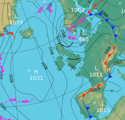
1st - 5th High pressure (HP) was in charge at the start of the month through to the 11th, but with two distinctively separate periods within that time. To start, the HP was centred and dominant in the Atlantic, but with low pressure (LP) to our east, the effect was to drag down a cool north-westerly flow (see synoptic chart below).
The HP in the Atlantic slowly moved east towards the UK, but it wasn't until the 6th when we saw a rise in temperatures. However, despite being a cool start to the month, it was dry with very little in the way of rain, confined to rare and inconsequential showers 2nd - 4th.
We had the pleasure of some sunny spells, but temperatures were suppressed with a low of 13.6°c (56.5°f) on the 3rd and which typically ranged from 15-16°c.
Mid-day 2nd - showing the high pressure in the Atlantic, low pressure near Norway, resulting in the cool north-westerly airflow
6th - 11th Come the 6th the HP was centred just west of Eire and the UK was now more under its direct control. Pressure rose to 1032.8 Mb on the 7th with the winds falling light and now from the south-east and with it a subsequent rise in the temperature and even more sunshine.
The 6-7th were gloriously sunny, with the 8th following suit after a misty start. The 7th notched up 20.4°c, but under clearer skies the nigh-time minima fell away sharply, both the 6-7th down at 2.5°c.
The HP slowly drifted across the UK and towards the north-west coast of Norway by the 9th, but in those south-east winds the temperature hit 20°c on both the 10th and 11th, the month's high of 20.7°c (69.3°f) falling on the 10th.
12th - 15th LP arrived overnight 11/12th bringing a spell of heavy rain, 15.5 mm credited back to the 11th, and which continued during the morning of the 12th. Whilst LP remained over or near the UK for the next few days, rainfall in Cumbria was negligible as we avoided any frontal systems. However, the temperatures fell away again, ranging 15-16°c (in fact the maximum temperature for the 14-17th was exactly the same each day, 15.4°c).
16th - 18th The LP then broadened out to a slack pressure gradient during the period and despite pressure falling to 991.1 Mb on the 16th it was a perfectly lovely sunny day after starting with the season's first ground frost, -0.1°c and a quite chilly month's low of 1.7°c.
Under clearer skies the night-time minima were on the low side and we again tended to avoid any frontal systems all apart from an occlusion during the evening of the 17th and overnight into the 18th, which gave 4.4 mm of rain.
18th - 20th HP in Biscay ridged north before being replaced by a frontal system off the Atlantic and we again had a few quiet days, the 19th pleasantly sunny and the best of the bunch as a weak occlusion brought an overcast and drizzly day on the 20th.
21st - 24th It then became a little mixed as frontal systems connected to LP near Iceland swept east overnight and during the morning of the 21st and which with some rain was quite a dark morning, before brightening in the afternoon.
This was followed by a quiet day on the 22nd under a weak ridge of HP, before a weakening frontal system, again connected to the LP near Iceland, drifted east 23rd, but which only brought cloudy skies and literally, the odd spot of rain.
Showers, some of which were moderately heavy, were frequent during the 24th as several trough lines were blown through on a brisk south-westerly.
25th - 30th And then the glorious end to the month. Not as warm as the last three days of 2011, but it was still a fine period, virtually summer-like with wall to wall sun, dry and pleasantly warm.
HP built to our south and moved north, becoming dominant and in control of the weather. The centre of the HP drifted out into the North Sea, then to southern Sweden, rising to 1038.9 Mb, before elongating east-west across the UK and northern Europe on the 30th. It was a case of cool by night with heavy dews and warm and sunny by day, it was superb.
Most of the days hardly saw a breath of wind as well and coupled to the sunny days the temperature steadily rose through the period from just 14.5°c (25th) to 19.6°c on the 29th.
Rainfall totalled 32.5 mm for the month, with rain recorded on 9 days of which 6 were 'Wet days' (1.0mm +).
The Mean Temperature for the month was 11.41°c -- The Mean Max' was 16.49°c -- The Mean Min' 6.33°c.
We had 0 Air Frosts in the month (year 42) -- Grass frosts totalled 2 (year 94).
The 1 foot soil temp ranged from a low of 12.2°c on the 28-30th to a high of 15.0°c on the 1st -- with a monthly mean of 13.6°c
The 1 meter soil temp ranged from a low of 12.3°c on the 30th to a high of 13.9°c on the 1st - 3rd -- with a monthly mean of 13.1°c
COMPARISONS:-
* September 2015 rainfall was 40.3% of the September average for 2007 - 2014
* September 2015 was 1.17°c colder than the September average for 2009 - 2014 and 0.9°c colder than the local long term average 1981-2010
* 2014 Jan - Sept TEMP 10.37°c -- RAIN 970.0 mm
* 2013 Jan - Sept TEMP' 8.96°c -- RAIN 703.3 mm
* 2012 Jan - Sept TEMP' 9.25°c -- RAIN 868.5 mm
* 2011 Jan - Sept TEMP' 9.62°c -- RAIN 904.5 mm
* 2010 Jan - Sept TEMP' 8.74°c -- RAIN 461.1 mm
* 2009 Jan - Sept TEMP' 9.77°c -- RAIN 791.9 mm
* 2008 Jan - Sept TEMP' -- RAIN 985.7 mm
This makes the Jan' to Sept' period of 2015 0.53°c colder than the average for 2009-14 and with 96.8% of average rainfall for 2008-14
JANUARY 2010
FEBRUARY 2010
MARCH 2010
APRIL 2010
MAY 2010
JUNE 2010
JULY 2010
AUGUST 2010
SEPTEMBER 2010
OCTOBER 2010
NOVEMBER 2010
DECEMBER 2010
JANUARY 2011
FEBRUARY 2011
MARCH 2011
APRIL 2011
MAY 2011
JUNE 2011
JULY 2011
AUGUST 2011
SEPTEMBER 2011
OCTOBER 2011
NOVEMBER 2011
DECEMBER 2011
JANUARY 2012
FEBRUARY 2012
MARCH 2012
APRIL 2012
MAY 2012
JUNE 2012
JULY 2012
AUGUST 2012
SEPTEMBER 2012
OCTOBER 2012
NOVEMBER 2012
DECEMBER 2012
SUMMER 2012
REVIEW OF 2012
JANUARY 2013
FEBRUARY 2013
MARCH 2013
APRIL 2013
MAY 2013
JUNE 2013
JULY 2013
AUGUST 2013
SEPTEMBER 2013
OCTOBER 2013
NOVEMBER 2013
DECEMBER 2013
REVIEW OF 2013
JANUARY 2014
FEBRUARY 2014
MARCH 2014
APRIL 2014
MAY 2014
JUNE 2014
JULY 2014
AUGUST 2014
SEPTEMBER 2014
OCTOBER 2014
NOVEMBER 2014
DECEMBER 2014
WINTER 2014
REVIEW OF 2014
JANUARY 2015
FEBRUARY 2015
MARCH 2015
APRIL 2015
MAY 2015
JUNE 2015
JULY 2015
AUGUST 2015
© Darren Rogers 2015
Want to comment on this site? email